piatok 17. júla 2020

Vector files for Map_ax and MAPSGO

Vektorové súbory pre Map_ax a MAPSGO.
Vector files for Map_ax and MAPSGO.


- - - - -  Slovensky - - - - -  

Android programy Map_ax  a  MAPSGO umožňujú zobrazenie vektorových súborov (body, línie, polygóny) nad rastrom.
Tieto vektorové súbory sú jednoduché textové súbory *.poi (body). *.lin (linie), *.pol (polygony).
Map_ax a MAPSGO otvoria aj *.gpx súbory (formát Garmin Nuvi, GPX Map Source).

Vlastné vektorové súbory je možné pripraviť:

1) Z internetových mapových zdrojov pomocou programu "ITN Converter".
2a) POI, LIN, POL súbory zo súboru *.kml pomocou programu "ITN Converter".
2b) GPX súbor zo súboru *.kml pomocou programu "ITN Converter".
3) Z vlastných mapových zdrojov - rastre bmp/bpw, tif/tfw, jpg/jgw a súbory *.shp pomocou programu "SHP_MGMX".

Program "ITN Converter" stiahnite tu:  "Download ITN Converter".

1) Z internetových mapových zdrojov pomocou programu ITN Converter.

a) Otvorte Editor.

b) Vyberte mapový zdroj a pridajte body ako waypointy.
- pre *.poi s názvom bodov.
- pre *.pol a *.lin bez názvu bodov.


c) Uložte ako *.csv (viď prílušné manuálne nastavenia).
- pre *.poi s názvom bodov.
- pre *.pol a *.lin bez názvu bodov.

d) Upravte príslušný *.csv súbor:
    - vymažte hlavicku (prvý riadok s názvami stĺpcov),
     pre poi:
    - uložte ako *.poi súbor.
     pre lin:
    - doplňte xxx na začiatok a koniec,
    - uložte ako *.lin súbor.
     pre pol:
    - doplňte xxx na začiatok a koniec,
    - uložte ako *.pol súbor.

Príklad "poi" súbor.
Názov bodu na začiatku.

Štefánika 3:49.109531:18.926597
Chotárna 7:49.109736:18.927676
Chotárna 1:49.109576:18.929197
Palackého 9:49.110848:18.931393
Palackého 2:49.109352:18.930950

Príklad "lin" súbor.
Každá línia je oddelená xxx znakom.

xxx
49.109349:18.931003
49.109644:18.928578
49.109742:18.927677
49.112046:18.929887
49.113127:18.927205
49.114265:18.925188
49.114560:18.924544
xxx

Príklad "pol" súbor (v prvom a poslednom riadku rovnaké súradnice).
Každý polygon je oddelený xxx znakom.

xxx
49.109572:18.929661
49.109838:18.929729
49.109877:18.930018
49.109547:18.929899
49.109572:18.929661
xxx


2a) POI, LIN, POL súbory zo súboru *.kml pomocou programu ITN Converter.
a) Otvorte *.kml súbor.

b) Uložte ako *.csv (viď prílušné manuálne nastavenia).
    - viď obrazy ako pri 1).

c) Upravte príslušný *.csv súbor:
    - vymažte hlavicku (prvý riadok s názvami stĺpcov),
     pre poi:
    - uložte ako *.poi súbor.
     pre lin:
    - doplňte xxx na začiatok a koniec,
    - uložte ako *.lin súbor.
     pre pol:
    - doplňte xxx na začiatok a koniec,
    - uložte ako *.pol súbor.


2b) GPX súbor zo súboru *.kml pomocou programu ITN Converter.
a) Otvorte *.kml súbor.

b) Uložte ako *.gpx (Garmin Nuvi, GPX Map Source).


3) Z vlastných mapových zdrojov - rastre bmp/bpw, tif/tfw, jpg/jgw a súbory *.shp pomocou programu SHP_MGMX.

Viac o programe SHP_MGMX pozrite   TU.  


- - - - - - - - - -
Rozdiel KML - KMZ:
Rozdiel medzi .KML a .KMZ je v tom, že súbor .KMZ je komprimovaný („zazipovaný“) pomocou aplikácie, ako je WinZip.
Súbor .ZIP je premenovaný na .KMZ (toto premenovanie je vykonané preto, aby počítač súbor automaticky rozpoznal ako súbor, ktorý je možné otvoriť v aplikácii Google Earth a nie vo formáte WinZip).

KML na KMZ: 
- Vytvorte súbor .KML (z aplikácie Google Earth ...)
- Pomocou programu WinZip skomprimujte súbor
- Premenujte príponu súboru zo .ZIP na .KMZ

KMZ na KML: 
- Premenujte príponu súboru z .KMZ na .ZIP
- Použite WinZip na rozzipovanie .ZIP súboru
- Rozzipovaný súbor je súbor KML
- - - - - - - - - -


- - - - -  English - - - - -  

Android apps Map_ax and MAPSGO allow the display of vector files (points, lines, polygons) above the raster. These vector files are simple text files * .poi (points). * .lin (lines), * .pol (polygons).
Map_ax and MAPSGO will also open * .gpx files (Garmin Nuvi format, GPX Map Source).

Custom vector files can be prepared:

1) From Internet map sources using "ITN Converter".
2a) POI, LIN, POL files from * .kml file using "ITN Converter".
2b) GPX file from * .kml file using "ITN Converter".
3) From custom map sources - raster bmp / ​​bpw , tif / tfw, jpg / jgw and * .shp files using "SHP_MGMX".

Download "ITN Converter here":  "Download ITN Converter".

Pictures about ways "1 - 2" are above.

More about "SHP_MGMX" look   "HERE". 


- - - - - - - - - -
KML - KMZ difference:
The difference between .KML and .KMZ is that a .KMZ has been compressed ('zipped' up) using an application such as WinZip.
The .ZIP file is renamed as a .KMZ (this renaming was done so that your computer would automatically recognize it as a file that can be opened in Google Earth and not WinZip).

KML to KMZ:
- Create your .KML (from Google Earth ...)
- Use WinZip to compress the file
- Rename the file extension from .ZIP to .KMZ

KMZ to KML:
- Rename the file extension from  .KMZ to .ZIP
- Use WinZip to uncompress .ZIP file
- Uncompressed file is .KML file
- - - - - - - - - -


Enjoy
JS

sobota 27. júna 2020

Map_ax - Android offline maps

Map_ax - Android offline mapy.


- - - - -  Slovensky - - - - -  

Použitie:

Map_ax sa dá použiť na:
- zobrazenie rastrových máp ( jpg / jgw  mapové súbory ),
- zobrazenie vektorových vrstiev (špeciálne súbory na txt báze),
- zobrazenie a uloženie bodov do txt a gpx súboru,
- zobrazenie bodových a polygonových popisiek,
- zisťovanie vzdialenosti (km) a výmery (ha),
- prácu s GPS .

Mapový formát:

Map_ax používa:  EPSG:4326 WGS 84

Rastrová mapa je vo formáte jpg s príslušným jgw súborom.
Príklad 6 riadkového jgw súboru:
0.000019900000
0.000000000000
0.000000000000
-0.000019900000
18.779963378850
49.156163579150

Map_ax nepoužíva:  EPSG:3857 WGS 84

Umiestnenie súborov:

* Na Internom (zdielanom) úložisku (nie na mikro SD karte) je adresár:
   Android / data / com.Map_ax / files
a v ňom sú:
- rastrové mapy (jpg/jgw).
- nastav.set s uloženými nastaveniami.
- txt, gpx súbory so súradnicami bodov, vektorové súbory (*.poi, *.pol, *.lin).

Nastavenia android zariadenia:

"Poloha" musí byť: "Zapnuté"  (Nastavenia - Poloha- Zapnuté).

Azimut sa nezobrazí ak zariadenie nemá senzor orientácie.

Vytvorenie vlastných máp:

"Mobile Atlas Creator" a "Maperitive".
Programy "Mobile Atlas Creator" alebo "Maperitive" nedokážu priamo vytvoriť mapy vo formáte jpg/jgw  (EPSG:4326 WGS 84).
Dokážu ale vytvoriť mapu vo formáte png/map  (EPSG:4326 WGS 84).

Cez "Mobile Atlas Creator" alebo "Maperitive" vytvor: OziExplorer (PNG & MAP) .
Prikaz v Maperitive na vytvorenie ozi map:
export-bitmap file=output.png ozi=true

1)
Vytvorí sa *.png obrazový súbor, ktorý treba prekonvertovať na *.jpg súbor (otvor png súbor napríklad v programe Windows Kreslenie a ulož ako jpg súbor).
2)
Vytvorí sa *.map konfiguračný súbor, ktorý treba prekonvertovať na *.jgw súbor (na konverziu použi aplikáciu „map_jgw“).
O príprave vlastnej mapy jpg/jgw pozri "map_jgw":     pozri TU  .

Na tvorbu vlastných máp je možné použiť aj program "Terra Incognita" by Marian Zubak.
Tento program vytvára priamo jpg/jgw rastrové mapy.
Terra Incognita pozri  TU .

O tvorbe vlastných vektorových súborov pre Map_ax pozri    TU     a     TU.   

"Map_axL" je free  lite verzia s ktorou môžete:
* uložiť maximálne 5 bodov do txt, gpx súboru,
* merať vzdialenosť a výmeru medzi max 5 bodmi.

Stiahnite *.apk súbor nižšie cez "HEREdownload".

Inštalácia APK súboru.
* Stiahnite APK súbor (Kliknite na "HEREdownload" a potom použite tlačidlo "Stiahnuť pomaly zadarmo"). 
* Ak ste stiahli v stolnom počítači, tak pomocou USB kábla prekopírujte APK súbor do Android mobilu (napr. do adresára Download). 
* V mobile pomocou súborového manažéra vojdite do adresára, kde ste APK nakopírovali a kliknite prstom na APK súbor. Začne inštalácia, pred ktorou pravdepodobne bude potrebné povoliť neznáme zdroje.
* Po nainštalovaní aplikácie môžete stiahnutý APK súbor zazálohovať a vymazať.


- - - - -  English - - - - -  

You can use Map_ax Android for to:

- display raster maps ( jpg / jgw ),
- display vector map layers (as a special files - like the txt files),
- display points and save the list of the points as txt and gpx file,
- measure the distance (km) and the area (ha),
- work with GPS.

Map_ax uses EPSG:4326 WGS 84

Raster map files (jpg/jgw), vector files (*.poi, *.pol, *.lin) and another files are stored in the:  "Android / data / com.Map_ax / files" folder in the Internal (shared) storage  (no micro SD card).

Settings of the android device.
"Location" has to be "Set On"  (Settings - Location - On).
The azimut is not calculated if the device has not the sensor of the Orientation.

You can create your own offline raster maps with:
- Mobile Atlas Creator,
- Maperitive.
More about the map creation look at  "map_jgw":     H E R E    

You can use also "Terra Incognita" (creates directly jpg/jgw) by Marian Zubak.    Look HERE . 

More about vector files creation for Map_ax look    HERE    and     HERE.  

"Map_axL" is free lite version and you can:
* save max 5 points in the txt, gpx file,
* measure the distance and area between max 5 points.

Structure of the vector map layers (polygons , lines , points) :

Vector files for Map_ax are simple txt files with the end of files *.pol , *.poi, *.lin .
You can create them with the Notepad,

Example of poly.pol file
In the *.pol file are the coordinates of the points of the polygons, separated with the xxx line.

Non labeled polygons

Labeled polygons.

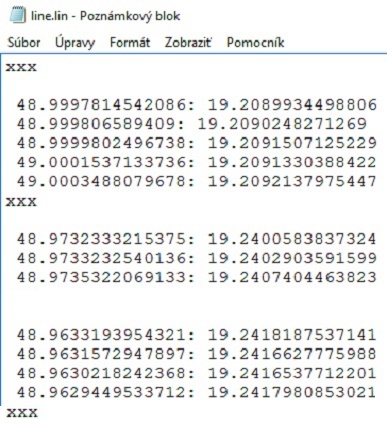
Example line.lin file
In the *.lin files are the coordinates of the points of the lines,  separated with the xxx line.

Example point.poi file
point name:latitude:longitude
-------------------------------------------------------------------------------------------

Structure of the point map layer  :

Points are gathered to the list with the GPS or from the map and the list of points is saved as *.txt file and *.gpx file.
Structure of the point txt file is:   
poi_name:latitude:longitude:altitude:accuracy:note


You can download free version for Android phones and tablets:     HEREdownload .

You can download free version for Oculus Quest:      HEREdownload .

You can download free version for Android TV:      HEREdownload .

You need Bluetooth Air Mouse for Androit TV app.


Privacy policy.
The app does not use any location access in the background.
The location access is only used when the app is running.
Google Play requires me to disclose that "Map_axL" APP uses the GPS only for to the gather the coordinates with GPS for offline map purpose. This APP do not send the coordinates to another persons nor devices.

Pravidlá ochrany súkromia.
Táto aplikácia nezbiera žiadne osobné informácie.
Táto aplikácia nepoužíva prístup k lokalizácii na pozadí.
Lokalizácia pomocou GPS sa využíva len pri spustenej aplikácii - ak používateľ klikne na ikonu "GPS".


Download Manual English (pdf) :        HEREmanual .

Stiahni  Prirucka   SK     (pdf)  is:        TuPrirucka .


Enjoy
JS

"map _ jgw" map file to jgw file.

"map_jgw" android app

Android aplikácia na konverziu OziExplorer map súboru na jgw súbor.
Súbory map sa nakopírujú do adresára:  Android / data / com.map_jgw / files
Do toho istého adresára sa konvertujú jgw súbory.


- - - - -  Slovensky - - - - -  

open ozi map - otvor map súbor
make jgw - vytvor jgw súbor ručným zadaním vstupných hodnôt
save jgw - ulož jgw súbor
x - vymaž vstupné hodnoty

Niektoré mapové programy používajú rastrové mapy vo world file formáte (jpg/jgw, png/pgw, bmp/bpw, tif/tfw).

Napríklad Android aplikácia "Map_ax" používa rastrové mapy vo formáte jpg/jgw  (EPSG:4326 WGS 84).

Programy "Mobile Atlas Creator" alebo "Maperitive" nedokážu priamo vytvoriť mapy vo formáte jpg/jgw  (EPSG:4326 WGS 84).
Dokážu ale vytvoriť mapu vo formáte png/map  (EPSG:4326 WGS 84).

1)
Vytvorí sa *.png obrazový súbor, ktorý treba prekonvertovať na *.jpg súbor (otvor png súbor napríklad v programe Windows Kreslenie a ulož ako jpg súbor).
2)
Vytvorí sa *.map konfiguračný súbor, ktorý treba prekonvertovať na *.jgw súbor (na konverziu použi aplikáciu „map_jgw“).

Príklad jgw súboru (6 riadkov):
0.000019900000
0.000000000000
0.000000000000
-0.000019900000
18.779963378850
49.156163579150

Takto vytvorený súbor jpg a jgw je možné použiť v aplikácii "Map_ax".

Mobile Atlas Creator
OziExplorer (PNG & MAP) .


Maperitive
OziExplorer (PNG & MAP) .
Prikaz v Maperitive na vytvorenie ozi map:

export-bitmap file=output.png ozi=true

Poznámka:
Programy "Mobile Atlas Creator" alebo "Maperitive" síce dokážu vytvoriť rastrovú mapu vo formáte png/pgw, ale takto vytvorený raster má formát EPSG:3857 WGS 84.


- - - - -  English - - - - -  

Convert OziExplorer map file to jgw file.
App uses folder:  Android / data / com.map_jgw / files

Some map programs use raster maps in world file format  (jpg/jgw, png/pgw, bmp/bpw, tif/tfw).
For example, the Android application "Map_ax" uses raster maps in the format jpg/jgw  (EPSG:4326 WGS 84).

Application "Mobile Atlas Creator" nor "Maperitive" cannot directly create maps in the format jpg/jgw  (EPSG:4326 WGS 84).
But they can create a map in the format  png/map  (EPSG:4326 WGS 84).

1)
A *.png image file is created, which needs to be converted to a *.jpg file (open png file, for example in Windows Painter, and save it as a jpg file).
2)
A *.map configuration file is created, which has to be converted to a *.jgw file (use the application „map_jgw“).

Example of the jgw file (6 rows):
0.000019900000
0.000000000000
0.000000000000
-0.000019900000
18.779963378850
49.156163579150

"Mobile Atlas Creator" or "Maperitive" can create a raster map in png / pgw format, but the raster created in this way has a format EPSG:3857 WGS 84.

- - - - -  Download - - - - -  


Download map_jgw:       HEREdownload     


Privacy policy.
"map-jgw" APP is free. 

Pravidlá ochrany súkromia
Táto aplikácia nezbiera žiadne osobné informácie.


Enjoy
JS

štvrtok 16. mája 2019

Drobné príbehy pre Android.

Drobné poučné príbehy zozbierané na internete.
V jazyku slovenskom.

Aplikácie pre Android.


Na posúvanie medzi príbehami môžete použiť aj tlačidlá hlasitosti .


Aplikácia obsahuje možnosť hovoreného textu formou TTS (prevod textu na reč).
<T> = tichý text
>O< = ozvučený text
Ak zvolíte kliknutím >O< tak bude príslušný text hovorený.

Podržte <T> alebo >O< a nastavte:
hlasitosť, rýchlosť čítania a výšku hlasu.

V Android zariadení musí byť pre TTS nainštalovaný slovenský hlas.
Ak nie je, tak čítanie nepočuť - nainštalujte ho z Google Play kliknutím na text - TU - nad tlačidlom "ZATVOR".

V "Nastaveniach" telefónu, v časti "Zvuk" nastavte "Hlasitosť médií".


Pribehy_1        stiahni T U .     

Pribehy_2        stiahni T U .     

Pribehy_365        stiahni T U .  


Pravidlá ochrany súkromia
Táto aplikácia nezbiera žiadne osobné informácie. Je bezlatná a bez reklám.


Pribehy_1

* 90 príbehov.
* Zdroje:
https://www.mojakomunita.sk/web/danielik.vozarovie/blog/-/blogs/bruno-ferrero-pribehy
https://frauellie.wordpress.com/2010/09/08/styridsat-pribehov-z-puste/
http://5o4u.com/bruno-ferrero-pribehy-na-vianoce/
http://www.myslienky.estranky.sk/clanky/male-pribehy-pre-potesenie-duse---nove.html
https://grkatinacovce.webnode.sk/na-zamyslenie/
http://mojsvet-myworld.blog.cz/1101/princezna-bruno-ferrero
http://www.farnostnizna.sk/clanky/pribehy-na-povzbudenie
https://ukulele.webnoviny.sk/clanky/krasny-pribeh-o-tom-ako-velmi-je-dolezity-vztah-stareho-otca-vnucika
http://blog.ludialudom.sk/dlh-kratky-pribeh-na-potesenie-duse/
https://www.danielarau.sk/poucny-pribeh-drevena-miska/#.XNmW69QzaUk
https://anjelskiposlovia.webnode.sk/bruno-ferrero/
http://pekaraul.blogspot.com/2015/05/bruno-ferrero.html
http://www.pozitivnemyslenie.estranky.sk/clanky/motivacne-a-poucne-pribehy-/bruno-ferrero---sila-myslienky.html


Pribehy_2

* 90 príbehov.
* Zdroje:
https://eduworld.sk/cl/22/sebarozvoj-a-motivacia/pribehy-na-zamyslenie
https://www.danielarau.sk/tag/pribeh-s-poucenim/#.XN2MXtQzaUk
http://mamsvojsen-pribehy.blogspot.com/
http://www.myslienky.estranky.sk/clanky/ve--ke-pravdy-v-malych-pribehoch.html
https://www.interez.sk/blog/15-kratkych-motivacnych-inspirativnych-pribehov-ktore-si-mal-precitat-kazdy-ukazu-vam-cestu-vzdy-ked-stratite-nadej/


Enjoy
JS

štvrtok 18. apríla 2019

English text with dictionary - Čítanie v Angličtine so slovníkom


English text with dictionary.
Čítanie v Angličtine so slovníkom.


------------------------------------------------------


-------------------------------------------------------


------------------------------------------------------


1 :  Tolstoy_1  (Lev Nikolajevič Tolstoj)                   DOWNLOAD

Text resource:


2 :  Easter_1  (Easter Stories)                                   DOWNLOAD

Text resource:  


Google Play - Pravidlá ochrany súkromia
Táto aplikácia nezbiera žiadne osobné informácie.

Privacy policy for Google Play
Google Play requires me to disclose that these apps do not collect Personal informations.
The each app is a Free app and is intended for use as is.

streda 17. apríla 2019

Android Dictionary EN-CZ, EN-SK, EN-GE, EN-FR


Slovník      Anglicko - Český ,      Anglicko - Slovenský .

Dictionary     English - Deutsche ,      English - Français .


Slovník Anglicko - Český
Slovník Anglicko - Slovenský


Stiahni EN - CZ :   T U .

Stiahni EN - SK :   T U .


Google Play - Pravidlá ochrany súkromia
Táto aplikácia nezbiera žiadne osobné informácie.


1) Nainštalujte program.

2) Zatvorte program.

3) Po nainštalovaní sa
     vytvorí podadresár:
Android/data/com.E_Dict_ENcz/files/
     pre český slovník,
Android/data/com.E_Dict_ENsk/files/
     pre slovenský slovník.
V podadresáry sú slovníkové súbory.

4) Slovníkové súbory majú príponu *.txx
     sú to obyčajné textové súbory vo
     formáte UTF8. Doplniť sa dajú
     v bežnom textovom editore (notepad...).

5) Slovník bude použiteľný s textami
     v anglickom jazyku ako prekladač.

POUŽITIE :


------------------------------------------------------------------------------------------


Dictionary English - Deutsche
Dictionary English - Français


Dovnload EN - GE :       H E R E


Dovnload EN - FR :            H E R E


Privacy policy for Google Play
Google Play requires me to disclose that these apps do not collect Personal informations.
The each app is a Free app and is intended for use as is.


1) Instal APP.

2) Close APP.

3) After instalation there is the folder 
Android/data/com.E_Dict_ENge/files/
or
Android/data/com.E_Dict_ENfr/files/
Dictionary files are in the folder.

4) The end of dictionary files is .txx
The dictionary files are simple UTF8 text files.

You can edit them by text editor (notepad ...).


HOW to USE :


Enjoy
JS

piatok 12. októbra 2018

TP360BL - android app for mapping with TruPulse rangefinder

TP360BL - android app for mapping with TruPulse rangefinder.

The TruPulse 360B model measures distance, azimuth and inclination.
It has got Bluetooth capabilities for wireless data collection.
Integrates with GPS for efficient GIS data capture.
Provides full measurement capability for mapping.

- - - - - - - - - -

TP360BL - android app.

Download  APK:       HERE 

Privacy policy.
"TP360BL" APP uses the GPS only for mapping purpose.
This APP do not send the coordinates to another persons nor devices.

1) Measure horizontal distance (m) and azimut ( 0°-360°) with TruPulse 360b.
2) Transfer data to Android device by Bluetooth.
3) Find out coordinates (WGS84) of the measurment post with Android device and save data as txt and gpx file. Datas are prepared for GIS mapping.

- - - - - - - - - -
A)
Tap on the label "TP360B-028552" (1) and write your own TruPulse identification in text box.
Tap again on the label for saving your own TruPulse identification.
You can find TruPulse identification in Android device in Bluetooth settings.
Passkey = 1111
B)
Power ON TruPulse device.
The mode has to be as "SD" mode in TruPulse.
Bluetooth has to be set ON in TruPulse.
Distance measure has to be "meters" in TruPulse.
C)
Tap on "Connect" button (2) and wait for "Status: connected" (3) .
TruPulse will be connected (3) with Android device and GPS (4) in Android device.
It starts working (5) after connection.
D)
Select a target such as a tree .
Look through the eyepiece of TruPulse and use the crosshair to aim to the target.
Press-and-hold the fire button on TruPulse to find out the distance and azimut.
Distance and azimut will are transfered to the Android device (6).
Long tap on the row (6) to delete record.
You can gather 5 points in TP360BL lite version.
E)
Save (8) records with coordinates (WGS84) as txt and gpx file.
You can write your own file name (7) or date file name wil be created (if textbox is blanc).
You can edit (10) the prefix name of the saved points (x ...).
Coordinates of the measurment post, point distance and azimut are saved as txt and gpx file in "TruPulse" folder in the Internal (shared) storage (no micro SD card).
"TruPulse" folder is created when the app is started first time.
Some Android devices have problem to open this folder from desktop PC after connection by USB cable.
Problem solution can be to rename the folder to "TruPulsen" and after that rename it again to "TruPulse" directly in the Android device.

- - - - - - - - - -

Bluetooth has to be set ON in TruPulse.

The mode has to be as "SD" mode in TruPulse.
Distance measure has to be "meters" in TruPulse.

You can find TruPulse identification in Android device in Bluetooth settings.
Passkey = 1111

- - - - - - - - - -
"Location" has to be "Set On"  (Settings - Location - On).
- - - - - - - - - -

Merge gpx files.

You can use GPX Editor or  EasyGPS or G7ToWin to merge GPX files.

Download GPX Editor   HERE  .

Download EasyGPS   HERE  .

Download G7ToWin  HERE  .


GPX to SHP.

You can use "gpx2shp" to convert gpx file to shp files (WGS84).

Download "gpx2shp"  HERE .

You need to download the file  gpx2shp-0.69_win_notest.zip.   Unzip it.
To use the program, you just drag and drop the GPX file on the gpx2shp.exe (executable file).
The output is called [gpxfilename]_wpt.shp (.shx, .dbf, and so on) if the GPX file contains points.
Or use Command Prompt Commands (cmd) .


Enjoy
JS