

- - - - - Slovensky - - - - -
Map_ax sa dá použiť na:
- zobrazenie rastrových máp ( jpg / jgw mapové súbory ),
- zobrazenie vektorových vrstiev (špeciálne súbory na txt báze),
- zobrazenie a uloženie bodov do txt a gpx súboru,
- zobrazenie bodových a polygonových popisiek,
- zisťovanie vzdialenosti (km) a výmery (ha),
- prácu s GPS .
Mapový formát:
Map_ax používa: EPSG:4326 WGS 84
Rastrová mapa je vo formáte jpg s príslušným jgw súborom.
Príklad 6 riadkového jgw súboru:
0.000019900000
0.000000000000
0.000000000000
-0.000019900000
18.779963378850
49.156163579150
Map_ax nepoužíva: EPSG:3857 WGS 84
Umiestnenie súborov:
* Na Internom (zdielanom) úložisku (nie na mikro SD karte) je adresár:
Android / data / com.Map_ax / files
a v ňom sú:
- rastrové mapy (jpg/jgw).
- nastav.set s uloženými nastaveniami.
- txt, gpx súbory so súradnicami bodov, vektorové súbory (*.poi, *.pol, *.lin).
Nastavenia android zariadenia:
"Poloha" musí byť: "Zapnuté" (Nastavenia - Poloha- Zapnuté).

Azimut sa nezobrazí ak zariadenie nemá senzor orientácie.

Vytvorenie vlastných máp:
"Mobile Atlas Creator" a "Maperitive".
Programy "Mobile Atlas Creator" alebo "Maperitive" nedokážu priamo vytvoriť mapy vo formáte jpg/jgw (EPSG:4326 WGS 84).
Dokážu ale vytvoriť mapu vo formáte png/map (EPSG:4326 WGS 84).
Cez "Mobile Atlas Creator" alebo "Maperitive" vytvor: OziExplorer (PNG & MAP) .
Prikaz v Maperitive na vytvorenie ozi map:
export-bitmap file=output.png ozi=true
1)
Vytvorí sa *.png obrazový súbor, ktorý treba prekonvertovať na *.jpg súbor (otvor png súbor napríklad v programe Windows Kreslenie a ulož ako jpg súbor).
2)
Vytvorí sa *.map konfiguračný súbor, ktorý treba prekonvertovať na *.jgw súbor (na konverziu použi aplikáciu „map_jgw“).
O príprave vlastnej mapy jpg/jgw pozri "map_jgw": pozri TU .
Na tvorbu vlastných máp je možné použiť aj program "Terra Incognita" by Marian Zubak.
Tento program vytvára priamo jpg/jgw rastrové mapy.
Terra Incognita pozri TU .
O tvorbe vlastných vektorových súborov pre Map_ax pozri TU a TU.
"Map_axL" je free lite verzia s ktorou môžete:
* uložiť maximálne 5 bodov do txt, gpx súboru,
* merať vzdialenosť a výmeru medzi max 5 bodmi.
Stiahnite *.apk súbor nižšie cez "HEREdownload".
Inštalácia APK súboru.
* Stiahnite APK súbor (Kliknite na "HEREdownload" a potom použite tlačidlo "Stiahnuť pomaly zadarmo").
* Ak ste stiahli v stolnom počítači, tak pomocou USB kábla prekopírujte APK súbor do Android mobilu (napr. do adresára Download).
* V mobile pomocou súborového manažéra vojdite do adresára, kde ste APK nakopírovali a kliknite prstom na APK súbor. Začne inštalácia, pred ktorou pravdepodobne bude potrebné povoliť neznáme zdroje.
* Po nainštalovaní aplikácie môžete stiahnutý APK súbor zazálohovať a vymazať.
- - - - - English - - - - -
You can use Map_ax Android for to:
- display raster maps ( jpg / jgw ),
- display vector map layers (as a special files - like the txt files),
- display points and save the list of the points as txt and gpx file,
- measure the distance (km) and the area (ha),
- work with GPS.
Map_ax uses EPSG:4326 WGS 84
Raster map files (jpg/jgw), vector files (*.poi, *.pol, *.lin) and another files are stored in the: "Android / data / com.Map_ax / files" folder in the Internal (shared) storage (no micro SD card).
Settings of the android device.
"Location" has to be "Set On" (Settings - Location - On).
The azimut is not calculated if the device has not the sensor of the Orientation.
You can create your own offline raster maps with:
- Mobile Atlas Creator,
- Maperitive.
More about the map creation look at "map_jgw": H E R E
You can use also "Terra Incognita" (creates directly jpg/jgw) by Marian Zubak. Look HERE .
More about vector files creation for Map_ax look HERE and HERE.
"Map_axL" is free lite version and you can:
* save max 5 points in the txt, gpx file,
* measure the distance and area between max 5 points.
Structure of the vector map layers (polygons , lines , points) :
Vector files for Map_ax are simple txt files with the end of files *.pol , *.poi, *.lin .
You can create them with the Notepad,
Example of poly.pol file
In the *.pol file are the coordinates of the points of the polygons, separated with the xxx line.
Non labeled polygons

Labeled polygons.

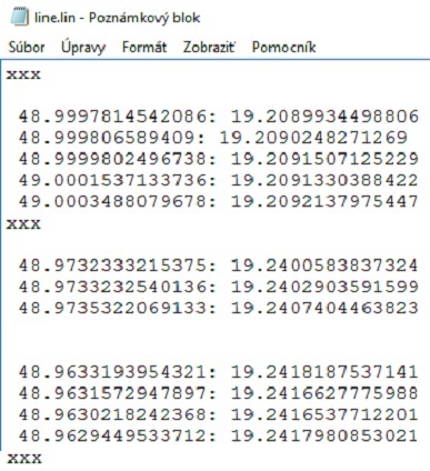
Example line.lin file
Example point.poi file
point name:latitude:longitude
-------------------------------------------------------------------------------------------
Structure of the point map layer :
Points are gathered to the list with the GPS or from the map and the list of points is saved as *.txt file and *.gpx file.
Structure of the point txt file is:
poi_name:latitude:longitude:altitude:accuracy:note

You can download free version for Android phones and tablets: HEREdownload .
You can download free version for Oculus Quest: HEREdownload .
You need Bluetooth Air Mouse for Androit TV app.
The app does not use any location access in the background.
The location access is only used when the app is running.
Google Play requires me to disclose that "Map_axL" APP uses the GPS only for to the gather the coordinates with GPS for offline map purpose. This APP do not send the coordinates to another persons nor devices.Pravidlá ochrany súkromia.
Táto aplikácia nezbiera žiadne osobné informácie.
Download Manual English (pdf) : HEREmanual .
Stiahni Prirucka SK (pdf) is: TuPrirucka .
Enjoy
JS
Táto aplikácia nepoužíva prístup k lokalizácii na pozadí.
Lokalizácia pomocou GPS sa využíva len pri spustenej aplikácii - ak používateľ klikne na ikonu "GPS".
Download Manual English (pdf) : HEREmanual .
Stiahni Prirucka SK (pdf) is: TuPrirucka .
Enjoy
JS


